Friday, June 19, 2009

From Natural Bridges to Monument Valley

Left Natural Bridges National Monument, I took to the road again. Today's main attraction was still to come. It would be Monument Valley (at sunset), and that was about 70 miles away. Besides, I planed to visit Goosenecks State Park and Mexican Hat on the way, so I gotta hurry.

Soon I was on Route 261. There was a warning sign at the beginning of it, "no trucks". I wondered why, because the road condition was quite good: it just meandered over the gently rolling terrain southward, in a lush forest of dwarf pinyon pines. The weather was good, sunny and breezy. At an altitude of 6500 ft, it was actually quite comfortable. There was very little traffic. I felt good driving on the lonely road.

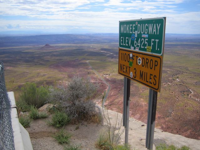
Then about 20 miles out, I suddenly learned why: there was a huge drop in the road and it was unpaved. Coming to the edge of Cedar Mesa, Mokee (Moki) Dugway took over. In the next 3 miles, it made several switchbacks on the side of the cliff, dropping 1100 ft in its course. Down there in the Valley of the Gods, was a desert decorated with buttes and painted hills. A vista so open and broad, everyone had to stop and enjoy.

Bell Butte in the foreground to the left, with Sugarloaf in the back.
I saw this board on the side of the road with lots of colorful stickers. Quite interesting. I wondered why this board was there to begin with. Not for those stickers, I guess?


I only learned the answer today!

Makeover of a road sign:

Here is a picture of this board copied from http://www.midwestroads.com/otherstates/mokidugway/

And another one on Flickr uploaded on Nov. 16, 2007 by Caddymob. Today was July 4, 2008. Go figure how fast it got covered up. I wonder how many people travel with stickers!

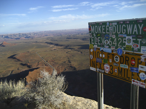
Last, this one (copied from http://www.imagesoftheworld.org/GrandCircle/mokidugway.html) seems to be the first photo of the road sign that I can find:


Looking to the south through mid-day haze, you can see Goosenecks in the foreground, and maybe Monument Valley in the background.
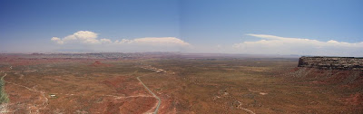
Looking southeast. Part of the switchback can be seen.
Looking east to northeast, Valley of Gods.

Route 316 off 261 brought us to Goosenecks State Park. Here San Juan River makes three 180-degree turns. The vista is so wide, I had to cover it with three shots with the widest angle. The following three shots were from left to right at Goosenecks. To see a good panoramic photo, click here.


At the right side of the second Gooseneck, looking southwest, on the far horizon was Monument Valley.
Looking back northwest towards Cedar Mesa:
Looking northeast towards Sugarloaf:

Last stop: Mexican Hat:

Wednesday, June 17, 2009

Mahjong: Contemporary Chinese Art from the Sigg Collection

I went to see the exhibition at the Peabody Essex Museum in April. Photography was not allowed for the majority of the collection. So here are the 3 pieces that I managed to document from over 120 works in the show. Do check out the slide show of the exhibition. There are some quite interesting stuff. For example, there is one digital photograph that looks very much like an abstract Chinese landscape painting, but in fact is just a photo of some naked butts, with hairs sticking out at various places, and even with mosquitoes on some of them. Hmm.

Back to what I got with my camera. The first one is the familiar figure in the above poster. He is seen in paintings, and as life-size sculptures in the hallway. He himself alone might seem silly, but the multiplicity makes him irresistibly hilarious.

2000 A.D. (2000) Yue Minjun, Painted polyester, 25 figures, each 74 x 18 in.


The second one is Boy Reading Mao Book (1998-1999) by Xu Yihui. What brings him to tears?


The last one is also work of porcelain, titled Obsessive Memories (2003), by Liu Jianhua. The poses are quite erotic!


Sunday, June 14, 2009

May Flowers

A short walk towards the end of May in my neighborhood yielded these pictures:

Columbines:

White bleeding-hearts:

I don't know what these are:

Ornamental onions:

Clematis: (count how many petals they have)

This year I feature irises:


Tuesday, June 09, 2009

Natural Bridges National Monument

Last summer in Utah, I saw arches and natural bridges. You may ask, what is the difference between these two types of features? One difference is where you may find these features: arches stand on the skyline whereas bridges form in the bottoms of deep canyons. Another difference could simply be a word play: by definition, a bridge is a structure spanning and providing passage over a river, chasm, road, or the like. In fact, a natural bridge forms when running water cuts away chunks of rock underneath. Arches and natural bridges come into existence when water erodes sandstone. Once water dissolves the cement between the grains of sand in a narrow fin of sandstone, frost wedging and gravity begin to work. While seeping moisture and frost shape arches, running water carves natural bridges. As the curving meanders of streams carved down into the sandstone, they undercut the canyon walls and bent back upon themselves until only a thin fin of stone separated them. Flash floods periodically pounded against weak spots formed by the soft siltstone layers in the sandstone. Eventually, the water cut through the narrow neck of the meander, forming a natural bridge.

There are 3 bridges in the Monument. A circular one-way road leads to the viewpoints to all three. Being on a rush schedule, I only hiked to the last bridge.

Sipapu Bridge is the largest of the 3 bridges. Sipapu means "the place of emergence," an entryway by which the Hopi believe their ancestors came into this world.


In the canyon there is the Horsecollar Ruin where Indian people once lived more than 700 years ago.

Kachina Bridge is believed to be the youngest of the 3 bridges. Kachina is named for rock art on the bridge that resembles symbols commonly used on kachina dolls. Under the bright sun and also because it is positioned at such an angle to the overlook, it is hard to see that it is a bridge. You will have to believe me that the big patch of green trees is where the water would flow underneath the bridge.

Owachomo Bridge is the smallest and thinnest, yet the oldest of the 3. Owachomo means "rock mound," a feature atop the bridge's east abutment. This should be on the left in the next 2 photos. Do you see it?


Even though Owachomo Bridge is thought to be the oldest, it is probably only about 5000 years old. This, in contrast to the age of the sandstone it is built upon (~260 million years), makes me think about ephemerality vs. eternity, and the relativity of everything.

Tuesday, June 02, 2009

Butler Wash Indian Ruins

An easy hike leads to the ruins.
The cliff dwellings in this area were built and occupied by the Anasazi about 1200 A.D., the structures represent daily life with living and storage rooms, along with ceremonial chambers. Only today did I learn that this site has been reconstructed and stabilized to some degree.

Can you see a natural bridge on the right?

A beautiful lizard on the hiking trail: